Thursday 26 June 2014

Heritage walk - Gowdall & Braithwell Railway: Warmsworth to Edlington

With a few hours to spare and in the mood for a walk, it was decided to investigate the route of the Hull & Barnsley and Great Central Joint Railway - also known as Gowdall & Braithwell Railway - which passes very close to where I grew up.


The line opened in 1916, connecting the Hull & Barnsley and Great Central Railways and was solely used for freight. Wikipedia states the first closure came in 1939, with this southern part of the line used for the storage of 'cripples' - wagons repairable but with no time and no facilities to do the work during the war.

Now the line is fragmented by housing estates, roads and motorway, but the lines of trees which mark its path make it clear to see from aerial maps.

Here is a 1952 map of the first half of our walk - we are following the curving line running from top to bottom, starting where it finishes its role as a part of the Trans-Pennine Trail from Sprotbrough at the 'clothes hanger' bridge over the River Don.


After the bridge the byway turns away up and right, and the route of the railway line continues straight on, turning into a boggy ravine.


The line then went under the main Doncaster to Sheffield line - this tunnel has been filled and sealed.


At the top of the ravine, overlooking the mainline, these trees on the left mark where the line would have emerged at the other side - a housing estate on the Balby-Warmsworth border sits over the route here.


We can reconnect via Guest Lane bridge which goes over the existing tracks nearby. Lines of trees within new housing estates mark the way (Heath Court and Mulberry Court).


There was a cutting here as the late 1980s which went through a bridge (under the bollards below) under the A630 - I remember playing underneath during the time it was being filled. It delineates the current border between Balby and Warmsworth.


The line went under Barrel Lane between these old trees and emerges as an overgrown raised bank in front of a small public space behind Lingfield Crescent.


The line now dissolves into the A1(M), then a long private driveway, and reemerges as the wall of the former bridge over Common Lane.


We used to ride our bikes up there but now the bank is overgrown. It went over Lord's Head Lane, but except for a drop towards the road, no trace of the bridge remains. Houses break the way briefly:


Just around the corner from this point is Warmsworth Park, which used to be lime kilns:


After the small estate, we cross Edlington Lane - there would have also been a bridge here. The rising road in the photo below is our route and is now called Warmsworth Halt - a reference to Warmsworth Goods Station. The line ran up here and also branched off to the left (where the trees are below), circling back towards Yorkshire Main colliery and then joining up with the Dearne Valley Railway.


Close by is the former pit-head wheel at the entrance to Yorkshire Main Miners' Welfare Club, with another further up the road behind Yorkshire Main Officials Club'.


We are also very near the site of the former 'Edlington for Balby, Doncaster' station on the Dearne Valley line. Our old map of the second half shows detail of both lines in this area - our route starts at the top and curves to the left; the east-west one is the Dearne Valley:


Other points of interest elsewhere on that map include the site of Blow Hall Manor, a site of a Roman coin hoard and on the far right, Alverley Grange or Hall. I got these from a great website which has many old Ordnance Survey maps.

As we continue up Warmsworth Halt, we are near the entrance to a water tunnel running to Conisbrough is still there - unfortunately I missed it but it must be somewhere on the right of this photo, among the trees.


At the end of the road the route turns back into a footpath and we are now walking along the western outskirts of Edlington.


We pass the point where the line crossed over the the Dearne Valley line and bearing left, continue on the dwindling path.


Note sure what this curved line of bricks would have been part of. We continue straight on.


Further on within the trees on the left of the above photo, evidence of the line in the form of a wall:


Finally we reach the Brickpit area, and the pleasant Martinwells Lake (marked as Gravel Pit in the earlier old map) and the footpath continues towards Conisbrough - maybe worth a continuation walk in the near future!


Wednesday 11 June 2014

Capturing Doncaster's follies

folly /ˈfɒli/ noun - a costly ornamental building with no practical purpose, especially a tower or mock-Gothic ruin built in a large garden or park (Oxford Dictionary)
18th and 19th century English estates would often feature temples, towers, summer houses and various other structures. These purposeless purpose-built ornaments were often eccentric and were built for pleasure, or perhaps to show off.

Many will have heard of or seen the impressive Wentworth follies near Rotherham, but how many know of Doncaster's own? Their locations form a crescent running from High Melton through to Barnburgh, Hickleton, Bilham and Brodsworth.

High Melton

Built in c1757, Melton Hall and its estate is now owned by Doncaster College's University Centre and features two follies. My reference guide Fabulous Follies by Ray Blyth refers to these as 'Grotto' and 'Icehouse'.

The grotto is thought to have been either a fernery, an aquarium or a greenhouse. It was found severely overgrown though the iron handrails over two bridges were still intact. A tree was growing in the centre and it was hard to see the floors from the internal bridges.


The inside - a bridge with handrail crosses the former pool below

The ice house is built into a gradient in the woods. Inside is a fairly deep (perhaps 15ft) pit which would have ensured a cool temperature for keeping food before the invention of refrigeration.


Barnburgh

The only remaining structure of Barnburgh Hall (demolished in 1969 by the National Coal Board for reasons of subsidence) is this 15th century octagonal dovecote, the village's oldest building. Easy to find on a piece of common land and as its name indicates, was designed to house doves (and possibly still does). 


If you're planning a visit, its worth mentioning the remains of the ancient St. Ellen's Chapel (not a folly) lie in a copse not far from here.

Hickleton

Hickleton's hall, gardens and estate are spectacular. The Hall itself was last owned by Sue Ryder (care homes) but is now in the process of being sold and the estate is owned by Halifax estates on behalf of the Earl of Halifax.

Here are some examples of various statues, plinths and ruins on the estate.


Within the grounds of the hall are two pavilions (one not pictured as not found), a 'classical seat' (not pictured as inaccessible), an ice house (not found), an urn in an attractive hedge arrangement and another headless statue.


Bilham

Looming at the end of a long, thin thicket is Bilham Belvedere, a c1800 summer house which was part of the former Bilham House. Now part of the Brodsworth estate, it can be seen from Hickleton golf course and there is a track leading from the road to its gate.


In the nearby Fish Pond Plantation is a plunge pool, described by Blyth as at least five feet deep.


On the edge of this wood is an arch, noted as 'Bilham Garden Seat' and probably used to be a summer house.


Brodsworth

At Brodsworth Hall there are at least three further follies. Target House (c1860) is a Swiss style summer house with Venetian windows. Another summer house, Doric Temple, built in 1866 looks towards the facade of another building which Blyth calls 'Eyecatcher'.

As the hall is an excellent attraction open to the public I've decided to not include these to not spoil any visit, but here's a link to its website if you're interested in going.

Sunday 8 June 2014

Stenigot revisit: tower climb

It was suggested to have a more in depth look at the radar mast at RAF Stenigot. A brief history of the site can be found on this previous report.


To recap, this is one of the few remaining towers of the WWII's Chain Home network, which provided an early warning of Luftflotte invasions into central England and is now used to train RAF aerial erectors.

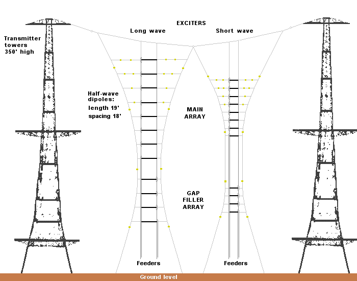
It's one of the transmitter masts and would have been one of four on the site, along with four receivers. This diagram gives some kind of explanation of how they worked:


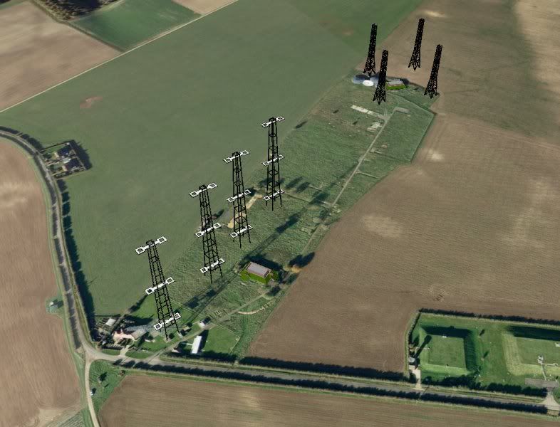
Here's an impression I found of how the site might have looked in its heyday:


Scaling the mast provides excellent views of the Lincolnshire countryside, and also detail of the structure itself.

Looking up

Sunrise from the first platform

Looking down


Looking north

Looking east

Looking south

Finally, here is a YouTube video of the ascent - thanks for viewing!