Monday 26 May 2014

RAF Stenigot

There are several interesting surviving features at this former radar station.

A 360 foot radar transmitter tower, a remnant of WWII's Chain Home network (map below), helped provide an early warning of Luftflotte invasions into central England.


Also, there remain four tropospheric scatter dishes. These were built in 1959 as one of the 82 stations which were part of the NATO's ACE High program, a long range cold war communication system. This is how they looked when in service:


The site was decommissioned in the 80s and mostly demolished in the 90s. The tower is now used by the RAF for its aerial erector school.

Tower


When in service there would have been a third pair of platforms, right at the top.


Tropospheric dishes


There are also a couple of remaining buildings - this is the outside of the 'transmitter block', and a pill box is nearby.

Thanks for viewing, await next communication!

Tuesday 20 May 2014

Northern Radar

There's a striking building to the west of the A614 between Hatfield Woodhouse and Blaxton.


This was part of former RAF Lindholme, named Humber Radar, later Northern Radar - a Joint Air Traffic Control Radar Unit (JATCRU). According to the South Yorkshire Historic Environmental Characterisation website,

A late addition to the RAF station at Lindholme is the cold war period Lindholme Tactical Control Centre, one of two surviving complexes of its kind in the UK from an original four (SMR ref: 4582). The buildings, which include the base of a Type 82 Radar Unit and the Tactical Control Centre itself, served as part of the Cold War Bloodhound Missile System, a network of control centres controlling 11 missile sites, mostly protecting the bases for the British V-Force air-launched nuclear deterrent - operational until the introduction of the submarine-launched Polaris system. The Monument Protection Programme considered this site to be of “National Importance” and recommended it be put forward for listing (Cocroft 2001).

Here is a photo from 1968 of the "operations room" - not sure if this means the radar unit or control centre - presumably the latter:


And this is a diagram I found at radarpages.co.uk of how the radar building would have looked fully equipped:

Type 82 Yeoman

In 1985 RAF Lindholme was sold and became HMP Lindholme. The prison buildings are to the east of the A614 - this area is on the other side. Wikipedia states:

The last RAF connection, an automatic routing installation, which opened on 25 May 1983 and was run by 840 Signals Unit was closed in March 1996. It occupied the old Northern Radar building ground floor, refurbished to accommodate the Telegraphic Automatic Routing Equipment (TARE) and a manual telegraphic switching centre and was parented by RAF Finningley. The TARE was a dual suite Ferranti Argus 500 computer system, each suite having a 64k word core store and two 2Mbyte hard drives and running software written using Coral 66.

Both buildings seem to be in good structural condition, and are well sealed. The lawn is being mown and a scrapheap has been built - it looks like a bonfire pile on one of the the circular hard-standings.

The radar building is known as a "Type 82 / Orange Yeoman"


Operational control centre


Over and out - thanks for reading!

Sunday 11 May 2014

William Nuttall's sweet factory, Doncaster

These Doncaster units, called Athron Industrial Estate in recent years, have been closed and gated for some time now, perhaps over a year.


The Holmes area of Wheatley was and still is a major junction - Broxholme Lane, Beckett Road, Wheatley Lane, Queens Road, Kings Road and Dockin Hill Road all come together here. Nowadays the Wheatley Hall Road dual carriageway passes alongside, and a new road and junction are being built on the other side - this will lead to the new Waterfront development.

There's plenty of reference to a Holmes Market, for which I can't find any details, but a quick search online reveals there were joiners and stonemasons based in this quarter in the 1860s. There's the shop parade there today which includes a motor shop and a mini supermarket.

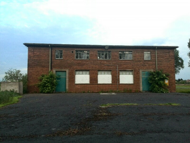
This industrial yard is where businessman and philanthropist William Nuttall's sweet factory was based. He died in 1934 and his name is also associated with the spinster cottages on Bennetthorpe. His confectionary company gave the world the Liquorice Lump and Mintoes:


This is the site where the minty, sticky chew originates. In recent times the estate housed car repair shops, a pickle factory, carpet and furniture warehouses and a dance studio and gym. There are several large factory rooms and the hoist arms, balcony and bridge fits in with manufacture of food stuff.

Now the place rots, and parts have been damaged by fires in July 2013 and January 2014. There's evidence of dwelling and one of the small garages may be being used for drug taking. Structural weakness and warnings of asbestos means it's not a recommended visit.

Rear, from Queens Road

 Into the yard

A look at the main building with hoist arm, balcony and bridge


Rear courtyard

 One of many messy offices

Fire damaged rooms

One of the upstairs rooms

In the dark recesses

The basement was used as a band rehearsal space. This is fluffy mold.

Some musical equipment remains

The right hand building most recently housed car workshops and a dance studio/gym


The upper floor has been fire damaged

Thanks for reading folks and do let us know if you have any more information on Holmes Market, Nuttall's sweet factory or anything about the site in general.

Saturday 10 May 2014

The derelict houses of Long Sandall

A few miles north east of Doncaster, bound by industrial estates, a noisy glass factory and a lock lies the village of Long Sandall.


Once an unloading point for cargo from the river Don, the place went from prosperity to near abandonment - according to A Brief History of Wheatley, boasted two inns as late as the 1860s.

This excellent report goes on to note:

...whilst the spread of  industrialisation caused Doncaster and its immediate neighbours to grow rapidly in the 19th Century, the same force eventually caused Long Sandall to decline as a major settlement.

The abundance of local sand encouraged the establishment of two major glass factories in the vicinity. Homes for the workers were built in the daughter village of Kirk Sandall and on the site of an old clay pit across Barnby Dun Road from Long Sandall. This latter became Clay Lane estate and grew rapidly to overshadow the older settlement.

By the 1970s, the number of households in Long Sandall had shrunk to less than twenty. Now there are just six, hidden from the outside world behind the huge Rockware Glass factory.

There are at least three still-upstanding abandoned buildings, though their gardens are now sometimes inhabited by a few tethered horses. There are a few mounds of bricks and so may well be more remains around the site.


Saturday 3 May 2014

N Corah & Sons

This company was established by Nathaniel Corah (1777-1831) and went on to become one of the most important hosiery and textile manufacturers in the UK.

HISTORY

The St. Margaret's Works site opened in 1865 as a result of the firm's expansion, and at one time employed over 1000 workers. In the 20th century the company had a close relationship with Marks & Spencer, and also provided clothing for the war effort.

At some point in the 1980s or 90s it closed its gates for good, although certain sections of the large complex are in current use, for example there's a skate park and some small textile units. There is further information on Leicester City Council's pageWikipedia and elsewhere.

THE VISIT

There are many large rooms strewn with textile debris - hangars, rails, boxes, files and paperwork, machinery plus other more empty ones. Some of the structure seems a bit flimsy - parts of the floor have a rotten, bouncy feel, and the place is full of pigeons and their droppings.

The following phone photographs show just a few areas of the plant as it was too big to cover in just a brief visit.

View from yard

This box room is a fire hazard - the place was subject to arson in 2012

One of the upper floors

One of many large rooms

A look across one of the yards. The more industrial section (including the boilerhouse) seems to be east toward the canal in front.

It looks like clothes were hung in here

This is the area that suffered from fire damage two years ago

A corridor - the graffiti was of a very good standard throughout
  The roof

Roof looking down - not sure what those hanging lengths were

Thanks for reading - until next time!