Showing posts with label Lincolnshire. Show all posts

Sunday, 28 May 2017

Haile Sand Fort

Following the outbreak of the First World War, English towns and cities like Hull, Grimsby and Immingham came under aerial attack, first from German airships, then aeroplanes.

Work started on building two forts on the mouth of the Humber Estuary in 1915. This one is off Humberston, Lincolnshire and Bull Sand Fort lies off Spurn on the Yorkshire side, seen in the distance below.


Soldiers were billeted in Cleethorpes (4000 by 1916), including at the Fitties camp which continues today as a chalet park. Up to 200 soldiers could stay on the fort itself.

It opened in 1917 and construction wasn't fully complete until 1918. It stands 59ft above the water ane has a diameter of 82ft.

Costing up to half a million pounds, according to Cleethorpes Heritage, no shot in anger was fired. Indeed, Bull Fort was so hard to build, built on sand 120ft down that it was only completed a month before the end of the war.

The effort was not wasted though as they were reactivated and modernised in WW2, seeing much action. They hosted "12pdr QFs and then 1940 with twin 6-pounders" (Victorian Forts). Netting was laid across the estuary to stop submarines entering.

Abandoned in 1956, both forts survive the sea's onslaught. Bull was bought by a charitable trust in 1997 for £21,000, with unrealised plans for a drug rehabilitation facility, while this one's on the market.

Accessing the fort

It sits a good mile from shore at high tide, and around 100 yards at low tide.


The tidal distance is huge here and when venturing from dry land, attention needs to be paid to the channel separating the vast high sands beyond. It's a 15 minute march to the lower-tide shore.

Wind and current affect conditions. An outgoing tide is beneficial for reaching it, but potentially unforgiving if turning around and swimming against it.

Around 100 years of being pounded by saltwater has made the ladders and wooden jetty treacherous, ready to collapse at the slightest tug. Rusted metal under the surface is an elaborate spike pit. Near the low tide mark: sea mushrooms—big, white bulbous growths attached to the edges.

Beams covered with barnacles and seaweed offer access to the platform.


The panels are weather scarred, rusty and colourful. Doors are sealed. There's no easy way of climbing up to the windows above. You're cold, with numb hands and feet. Your chest and stomach get cut climbing down. You swim back. 

Thursday, 17 July 2014

A taste of Lincolnshire's military history part 3 of 3: Stallingborough Heavy Anti-Aircraft Gun Site

For the final instalment of this series we go back to WW2 and a site which helped protect the Humber from air attack.

Stallingborough Heavy Anti-Aircraft Gun Site

A 3.7 inch gun site was in place here from June 1940 until May 1944, when it became one of 15 sites in the UK where 5.25 inch guns were mounted, of which 6 survive in some form today.
Example of a 5.25 AA gun at Heugh Battery Museum, Co. Durham

This one is in Gibraltar

The site is Grade II* listed as a result of its rarity, survival and technological, historical and social interest.

All four emplacements with their engine houses survive, plus the command post, guardhouse/gunstore and the generator house.

The British Listed Buildings website notes that "the design of the command post suggests that this was a gun site that employed female soldiers from the ATS, one of the milestones passed during the Second World War in the furtherance of equality between the sexes".

The guns remained in operation until as late as 1955. A Royal Observer Corps (ROC) post was constructed in 1961 and is also listed - presumably it is in good condition, but there wasn't chance to check during this visit.

Rod Collins' excellent website has a page dedicated to the site and includes first hand accounts of life on the site from a Len Copsey, including snippets such as

Re: [...] the compartments in the concrete surround, the 90lb projectiles (shell) were placed in there also the 56lb cordite explosive cartridge case so that as the Gun traversed to follow it target ammunition was always to hand on its 360 degree turning circle, the shell was passed up to the fuse setter, and placed in the trough with the cartridge behind moved over to the ramming position and brought back this was all done to chanting numbers = seconds of time until you reached as fast as possible, the Gun was operated by Hydraulic Pump powered by a Crossley Diesel Engine which were bastards to start...

Now covered by woodland, it provided an interesting exploratory.

One of the 4 emplacements


One of the entrances to a long part-submerged building, perhaps the command post

Looking into one of the bunkers - a torch would have been useful

Unfortunately at this point the phone camera battery went so sorry to not be able to bring you more!

Thanks for reading - that concludes this three part debrief. Click the "older posts" link below to see the previous two, or mobile readers can swipe left and right.

Wednesday, 16 July 2014

A taste of Lincolnshire's military history part 2 of 3: RAF Caistor

This post follows on from part 1 of a recent tour of 3 former military sites in Lincolnshire.

RAF Caistor

Built in 1940, Caistor was a minor RAF base, serving as a relief airstrip and training base during WW2, then returned to agricultural use afterwards.

In July 1959 however, it served as one of the 5 Thor missile stations of the Hemswell group as part of Project Emily, the US-UK deployment of intermediate-range ballistic missiles (IRBMs) on 20 sites in the east of England. 4 years later Thor was phased out and this site quickly returned to agricultural use.

English Heritage have a very informative advice report that gives more historical detail. It concludes as the site is so eroded, it won't be listed.

From the air we can see the tell-tail signs of a Thor site, specifically three cross-shaped hard-standings in a triangular arrangement, with two L-shaped blast walls at the intersection of each cross.


This diagram helps explain the function of the parts that are left, though as no L-shaped blast wall is shown, it doesn't seem to be an exact representation of this particular site.


The emplacements were found deserted with evidence of recent poultry production and fly-tipping. In the photo below a blast wall is on the right. The missile would have laid in a shelter where the shed is now.

Another blast wall with dumped junk

According to the diagram, this concrete trough could have been the liquid oxygen overflow basin

Looking into one of the sheds - nothing of interest except the remaining hard standing.

A locked auxiliary building - perhaps fire related.

More old poultry sheds. Unable to tell whether they ever had RAF use.

Thanks for reading- stand by for part 3!

Tuesday, 15 July 2014

A taste of Lincolnshire's military history part 1 of 3: RAF Hemswell

Lincolnshire is awash with WW2 and Cold War relics such as old RAF bases, radar stations, anti-aircraft batteries, coastal gun sites and even intermediate-range ballistic (IRBM) missile sites.

For this investigation, three sites were identified as having potential to offer a glimpse into the area's military heritage: RAF Hemswell, RAF Caistor and Stallingborough heavy anti-aircraft gun site, and so an afternoon was made of it.

Part 1 - RAF Hemswell

Located a few miles east of Gainsborough, construction of the base as a bomber airfield began in 1935, opening 1937. According to the informative 'Forgotten Airfields' site,

Hemswell's Hampdens are credited with being the first Bomber Command aircraft to drop bombs on German soil on the night of 19 March 1940 during an attack on the seaplane base at Hornum.

Aerial shot of the site during WW2 (from Forgotten Airfields)

Various RAF units were based there after the war, then in 1958 the base became an American Thor IRBM missile unit, which was headquarters for the Lincolnshire group that also included RAF Caistor, RAF Bardney, RAF Coleby Grange and RAF Ludford Magna.

A Thor PGM-17 missile being tested

Altogether there were 20 such sites in the east of England, each harbouring 3 missiles with thermonuclear warheads trained on the Soviet Union. The endeavor was codenamed Project Emily and the missiles were put on full alert during the Cuban missile crisis of 1962, before being superseded by inter-continental ballistic missiles (ICBMs) based on American soil.

According to Wikipedia, these missiles were returned to the US in 1963 and the RAF last used the site in 1974. Now the hangars are in commercial use, the technical buildings are used by traders, particularly antique dealers, and the domestic area is now the pleasant residential village of Hemswell Cliff.

A contemporary aerial photo looking south

What was most intriguing was an area in the north east corner of the site (in the bottom left of the above photo), which from above looks like 12 bunkers or pill boxes - a lot different to the usual Thor missile emplacement layout, which was not found. This mysterious section was found to be heavily fortified, with many cameras.

During inspection (from outside the fence) a couple of workers from the area containing the vast grain silos approached and one kindly asked if he could help. When asked about the facility one initially said there were big fireworks in there, but when pressed for more detail said that the area was 'just storage'. Whatever is being stored here is being done so very securely.

On with the photos, starting with the remains of one of the airstrips.

It was unclear what function this building near the runway used to serve.

Now tyres have been dumped there.

This is the area of most interest - note the razor wire, cameras, blast walls and heavy metallic units.


Aerial view of the above area

If anyone knows what was and/or still is in here please get in touch as it would be very interesting to know.

Update
Thanks to help from the 28DaysLater forum, it's been confirmed this is a storage area for a fireworks company (formerly an explosives/bomb dump when in RAF use).

Part 2 takes in former RAF Caistor - click here to launch!

Sunday, 8 June 2014

Stenigot revisit: tower climb

It was suggested to have a more in depth look at the radar mast at RAF Stenigot. A brief history of the site can be found on this previous report.


To recap, this is one of the few remaining towers of the WWII's Chain Home network, which provided an early warning of Luftflotte invasions into central England and is now used to train RAF aerial erectors.

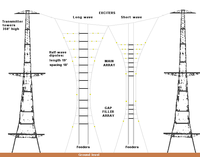
It's one of the transmitter masts and would have been one of four on the site, along with four receivers. This diagram gives some kind of explanation of how they worked:


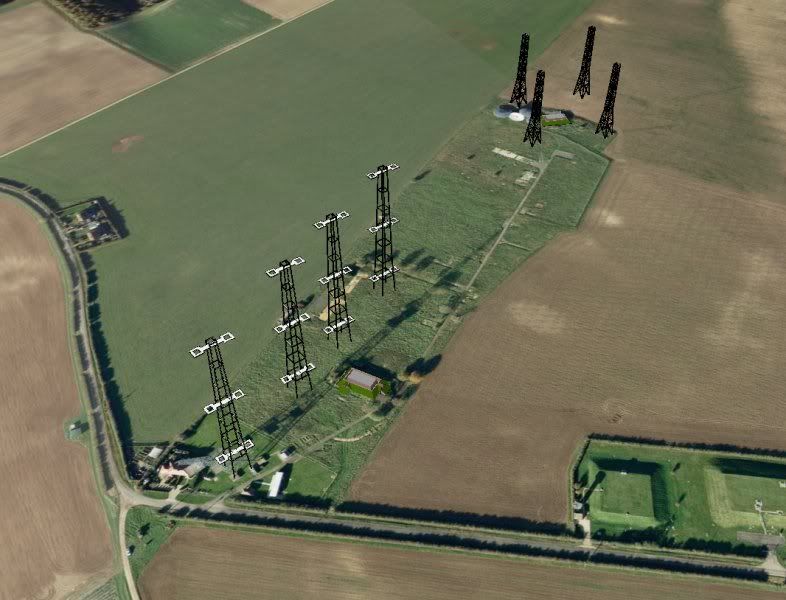
Here's an impression I found of how the site might have looked in its heyday:


Scaling the mast provides excellent views of the Lincolnshire countryside, and also detail of the structure itself.

Looking up

Sunrise from the first platform

Looking down


Looking north

Looking east

Looking south

Finally, here is a YouTube video of the ascent - thanks for viewing!


Monday, 26 May 2014

RAF Stenigot

There are several interesting surviving features at this former radar station.

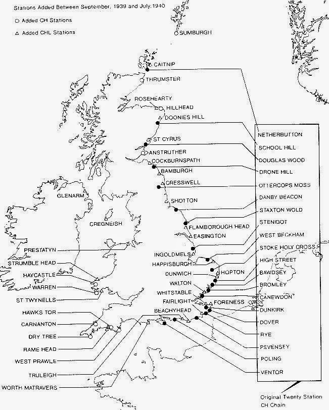
A 360 foot radar transmitter tower, a remnant of WWII's Chain Home network (map below), helped provide an early warning of Luftflotte invasions into central England.


Also, there remain four tropospheric scatter dishes. These were built in 1959 as one of the 82 stations which were part of the NATO's ACE High program, a long range cold war communication system. This is how they looked when in service:


The site was decommissioned in the 80s and mostly demolished in the 90s. The tower is now used by the RAF for its aerial erector school.

Tower


When in service there would have been a third pair of platforms, right at the top.


Tropospheric dishes


There are also a couple of remaining buildings - this is the outside of the 'transmitter block', and a pill box is nearby.

Thanks for viewing, await next communication!