Saturday, 9 December 2017

Welcome to Hel

A 20 mile long wooded sand bar peninsula lies off Poland's Baltic coast.

Hel peninsula
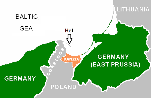
Poland and Germany after WW1
After WW1 it was a crucial part of Polish corridor to the sea. They built it up militarily in the 1930s in response to the Nazi threat with a naval base, underground power plant, underground petroleum reservoir and extensive artillery.

The Battle of Hel was Polish forces' last stand in 1939. 2,800 soldiers held out against all odds, dynamiting a narrow section to create an island, surrendering a month later.
Hel peninsula
Landsat photo
During WW2 the Germans built a U-boat training facility, batteries, a radar station and started work on an airfield. However in May '45 the roles were reversed. German soldiers with refugees, having fled from the mainland, fought for six days after Germany had surrendered before they themselves surrendered to the Soviets.

Under Communist rule the spit became one of the most protected military areas in the country. In time coastal artillery became less important, and most of what remained was designated military monuments in 1999.

The whole length is strewn with relics. We hoped to rent bikes to see more, but alas found none and just explored the part near the town of Hel on foot. I didn't note which were Polish, German or Soviet, but here's an idea what's there:

Gun battery

Trench

Gun turret

Inside the radar tower
Looking down from the radar tower

Entrance to the radar tunnel

Inside the radar tunnel


Battery command centre

Fire command post

Gun battery

Gun emplacement
A must visit for anyone visiting northern Poland.


Sunday, 3 December 2017

Upper Heyford's hardened buildings

Dogged reminders of 20th Century global conflict sit on a plain near Bicester in Oxfordshire.

Upper Heyford is the best preserved Cold War base in Britain, with hundreds of fascinating concrete structures, and there's always something new to discover.


The former RAF base was allocated to the USA's Strategic Air Command in the 1950s. Its purpose was to retaliate with bombers to any Soviet nuclear strike, which would lead to mutually assured destruction (MAD).

Tension must have been high during the Cuban missile crisis of 1961 when the end of the world looked possible—it would have started from here. But by the late 60s America's focus had shifted toward places such as Vietnam, and development here slowed for a time.

Then in the 70s, they pursued a more 'flexible response' strategy, and F-111 bombers arrived. The Arab-Israeli War had shown unprotected aircraft were vulnerable to attack, so they built new bombproof hangars and buildings.

Building number 299 – Avionics

The aircraft electronics facility is in the south-west of the airfield, near the main vehicular entrance. The nature of the work meant nothing magnetic was allowed in.


Building number not known – Quick Reaction Alert (or Victor Alert) entrance

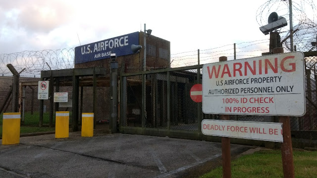
Behind this guard house, nine F-111s stood in concrete hangars on 24-hour standby, ready to attack Moscow.

Quick Reaction Alert (or Victor Alert) entrance


2010 – QRA Command Centre

The command centre for the planes on standby.


234 – 55th Aircraft Maintenance Unit

Just north of the QRA area is one of the squadron headquarters. Staff looking after the standby aircraft worked here. Historic England gives this one a separate listing, thanks to its completeness and good condition. It's now part of a police training area.

55th Aircraft Maintenance Unit

383 –  42nd Electronic Countermeasures Squadron HQ

This is newer than the other three squadron HQs. Like the others, it has a normal entrance and a 'dirty' one, connected to decontamination showers for anyone coming in with radiation.

42nd Electronic Countermeasures Squadron HQ

209 – 77nd Tactical Fighter Squadron HQ

Now occupied by a business, it's identical to the 55th and 79th squadrons' buildings. 


# n/k – Northern Bomb Store entrance 

Fortress guarding the nuclear bomb storage area:


1017 – Trigger Store

This held the capsules, or trigger mechanisms for the nukes. 

Front
The windows are fake, to make it look like an office. According to Historic England's 2017 "A reassessment of the flying field Conservation Area" report,
It is […] a solid concrete block, with a small, secure interior vault where nuclear capsules, or triggers might be stored. The capsules were held in pressurised tubes within a rectangular, open, tubular frame, known as a "Birdcage", and kept in the vault in open lockers about 0.91cm square. The vault might house up to 30 devices.
Rear
Vault

370 – 79th Tactical Fighter Squadron HQ

Within the car distribution area in the south, this is one of the least taken care of buildings at the base. Nature is taking over, on the outside at least. 

79th Tactical Fighter Division HQ
Exterior

Interior
Decontamination shower

Console for controlling entry

129 – Telephone Exchange

Built to maintain lines of communication in the event of an attack; it's still in use. 


126 - Command Centre

The nerve centre of the base was built in a nondescript corner of the airfield to hinder identification by the enemy.


Upper Heyford's civilian side is being turned into a busy commuter village. These striking buildings on the airfield are thankfully protected from the bulldozers by their listed status, and from the elements by their defensive, weatherproof designs.
For more photos of Upper Heyford see an earlier post.  

Sunday, 28 May 2017

Haile Sand Fort

Following the outbreak of the First World War, English towns and cities like Hull, Grimsby and Immingham came under aerial attack, first from German airships, then aeroplanes.

Work started on building two forts on the mouth of the Humber Estuary in 1915. This one is off Humberston, Lincolnshire and Bull Sand Fort lies off Spurn on the Yorkshire side, seen in the distance below.


Soldiers were billeted in Cleethorpes (4000 by 1916), including at the Fitties camp which continues today as a chalet park. Up to 200 soldiers could stay on the fort itself.

It opened in 1917 and construction wasn't fully complete until 1918. It stands 59ft above the water ane has a diameter of 82ft.

Costing up to half a million pounds, according to Cleethorpes Heritage, no shot in anger was fired. Indeed, Bull Fort was so hard to build, built on sand 120ft down that it was only completed a month before the end of the war.

The effort was not wasted though as they were reactivated and modernised in WW2, seeing much action. They hosted "12pdr QFs and then 1940 with twin 6-pounders" (Victorian Forts). Netting was laid across the estuary to stop submarines entering.

Abandoned in 1956, both forts survive the sea's onslaught. Bull was bought by a charitable trust in 1997 for £21,000, with unrealised plans for a drug rehabilitation facility, while this one's on the market.

Accessing the fort

It sits a good mile from shore at high tide, and around 100 yards at low tide.


The tidal distance is huge here and when venturing from dry land, attention needs to be paid to the channel separating the vast high sands beyond. It's a 15 minute march to the lower-tide shore.

Wind and current affect conditions. An outgoing tide is beneficial for reaching it, but potentially unforgiving if turning around and swimming against it.

Around 100 years of being pounded by saltwater has made the ladders and wooden jetty treacherous, ready to collapse at the slightest tug. Rusted metal under the surface is an elaborate spike pit. Near the low tide mark: sea mushrooms—big, white bulbous growths attached to the edges.

Beams covered with barnacles and seaweed offer access to the platform.


The panels are weather scarred, rusty and colourful. Doors are sealed. There's no easy way of climbing up to the windows above. You're cold, with numb hands and feet. Your chest and stomach get cut climbing down. You swim back. 

Saturday, 18 March 2017

Orford Ness, AWRE and Cobra Mist

Secret military activity on Suffolk's Orford Ness peninsula dates back to the First World War when the MOD took it over and built a Royal Flying Corps airfield on the marshes.


The remoteness of this 12 mile long shingle spit made it suitable for experimenting with aerial machine guns, bombs, navigation, photography and parachutes, which continued in the interwar period.

Radar's early development


The Orfordness Beacon (set up in 1929) was one of the earliest experiments in long range radio navigation, then in the mid 1930s work started on a new defence system that became known as radar.

Led by Sir Robert Watson-Watt, early work took place in the old WW1 huts before moving further down the coast to Bawdsey Manor. Their work brought about the Chain Home network, instrumental in overcoming the German threat from the air.

Second World War

Though the airfield was not used, the Aeronautical Armament Experimental Establishment was based here. Activities included "assessment of the vulnerability of aircraft to hostile fire" (English Heritage).

More buildings went up on 'The Street' and batteries were built to counter VI Flying Bomb guided missiles.

Atomic Weapons Research Establishment and 'controlled ruination'

Ballistics observation tower

From 1953 to 1971 the AWRE had a base here and conducted environmental testing on explosives including Britain's first atom bomb, Blue Danube.

According to English Heritage's detailed report, in 1960 the Establishment stated "there will be no tests involving the release of radioactive matter".

However, it describes how one former employee said tests were done with "either high explosives or their fissile/fusion components, but never both together", and "remembered being present during an overnight test on a system with components made of plutonium".

Laboratory 1


Laboratory​ 3


Laboratory​ 2


The structures were designed to contain any accident, like the Vibration Test Buildings or pagodas, whose roofs would collapse
and seal any explosion with concrete and shingle.


Since 1993 this part of the peninsula has been owned by the National Trust whose policy is to allow the site to decay while minimising human interference. 

Survivors of high pressure, shock, extreme temperatures and high vibrations, the buildings' main threat is the encroaching sea, constantly eroding and reshaping this fragile environment.

Cobra Mist, a $1 billion folly


Further north, construction began in 1967 on a new Anglo-American project codenamed Cobra Mist.

AN/FPS-95 441a was an over-the-horizon (OTH) radar system pointed at Moscow, designed to monitor soviet activity.

Testing began in 1971 but in 1972 problems emerged with noise interference affecting reception for which no explanation was found. Spyflight suggests the Russians could have been to blame, its signals jammed by agents in a trawler in the North Sea.

The USAF gave up and left in June 1973. Costing around $1 billion in today's money, it was the largest, most powerful and sophisticated OTH radar at the time with a broadcast signal of 10MW. 

Globalsecurity.org gives an impression of what the array might have looked like before removal in the mid 1970s.
"...a huge fan-shaped array of aerials supported on masts from 42 feet to 195 feet high. The antenna consisted of 18 log-periodic antenna strings, which radiated like spokes in a wheel from a central "hub." Each string was 2,200 ft in length and carried both horizontal and vertical radiating dipoles. The strings were separated by 7 deg in angle, and they thus occupied a 119-deg sector of a circle. The complete antenna was located over a wire-mesh ground screen, which extended beyond the strings in the propagation direction."


Spyflight says
"The radar was controlled from a large steel blockhouse which stood on short legs behind the array and was connected to the array by cables running to an underground chamber, lined with copper, in front of the array."


The above photo is at the 'hub' of the fan, but no underground chamber was found. Taught lines of wire remain on parts of the ground, remnants of the wire mesh screen.

The 80 acre expanse is a now a haven for wildlife, from rare insects, plants and fungi to grey canine-like animals that when startled bolt toward the main building. 

Orfordness Transmitting Station - the BBC looks east

In the late 1970s the Cobra Mist site came under control of the Foreign Office as Orfordness Transmitting Station, and from 1982 to 2011 was owned by the BBC, broadcasting the World Service to continental Europe.

Wikipedia describes the three types of aerial:
"The directional aerial for 648 kHz (erected in 1981-82) consisted of a row of five 106.7 metre (350 ft) freestanding steel lattice towers of triangular cross section."


"The directional aerial for 1296 kHz (erected in 1978) consisted of six freestanding steel lattice towers. Unlike the directional aerial for 648 kHz, they were arranged in two parallel rows with three towers in each." 


"There was also a back-up omni-directional mast radiator for 648 kHz (erected in 1983), which could only handle transmitter powers of up to 250 kW and was only used when maintenance work was being carried out on the directional antenna"

Future plans

The site closed then transferred to private ownership in 2015. Martin Fletcher visited last year for the Economist's 1843 Magazine and described the Cobra Mist building:


"Empty halls except for one that was filled with huge grey transmitters [...] an old glass-fronted control centre, rooms within rooms to thwart electronic eavesdropping, inner sanctums with beryllium-coated steel doors and handles on the inside only. Labyrinthine passages to offices with fading maps of Europe on the walls, tool shops, a canteen, a recreation room, a sick bay, old filing cabinets and packing cases stuffed with who knows what. Internal staircases descending into the murky flood waters below."

1843 Magazine

Interviewed, the new owner said he bought it as "it's a folly of grandiose proportions" and hopes to create local employment. Broadband, communications, a data centre and a solar farm are mooted as potential new uses for the site.